
For most of the last three years, anyone planning a Pacific Coast Highway road trip had to deal with an uncomfortable truth: the most famous stretch of the entire route, the wild cliffside section through Big Sur, was partially closed. A major landslide in January 2023 took out part of the road near Big Sur, and just as repairs were underway, a second landslide at Regent’s Slide compounded the damage, creating a 27-mile closure that forced a frustrating inland detour for years.
That changed on January 14, 2026, when Caltrans fully reopened the final closed section at Regent’s Slide, restoring uninterrupted travel along the entire Pacific Coast Highway through Big Sur for the first time in three years. If you’ve been waiting to drive this route without dealing with detours and partial access, 2026 is genuinely the best year to do it in recent memory.
This guide covers the complete Pacific Coast Highway from Southern California to the Bay Area and beyond, current road conditions, what to actually prioritize, and the planning details that matter on a route notorious for narrow, cliffside driving and occasional closures. If you’re connecting this with a broader Western U.S. itinerary, our Las Vegas guide and Route 66 road trip guide cover nearby routes worth combining with a coastal drive.
Table of Contents
The Pacific Coast Highway, officially California State Route 1 for most of its length, runs along the California coastline, with the most famous and frequently driven section spanning roughly from Los Angeles to San Francisco — about 450-500 miles depending on exact start and end points, though the highway technically continues further north and the broader “PCH road trip” concept often extends south into Orange County and San Diego as well.
Current Road Conditions: What Changed in 2026
This is worth addressing directly before anything else, since outdated road condition information is the single most common source of frustration for Pacific Coast Highway travelers planning around a recent landslide history.
As of January 14, 2026, Highway 1 is fully open through Big Sur, including the previously closed Regent’s Slide section in Monterey County. Throughout the closure period, the highway through Ragged Point, San Simeon, and Cambria in the southern Big Sur area actually remained open and accessible — it was specifically the connection further north, near Regent’s Slide, that cut off continuous travel.
That said, the Pacific Coast Highway is a route that experiences regular, often brief closures, and treating any current-conditions claim as permanent is a planning mistake. Caltrans performs ongoing slope stabilization and maintenance work throughout Big Sur, and storm-related closures (rockslides, flooding, downed power lines) remain a real possibility, particularly during the winter rainy season. Always check the Caltrans QuickMap for current conditions in the days before your trip and again the morning you’re driving through Big Sur specifically.
A separate, unrelated set of lane closures has affected the Los Angeles-area section of the Pacific Coast Highway through Pacific Palisades and Malibu, tied to ongoing repair and reconstruction work following wildfire damage in that corridor. These typically involve reduced speed limits and single-lane closures during weekday daytime hours rather than full closures, but they’re worth factoring into timing if your route passes through this specific stretch.
Planning Your Pacific Coast Highway Route: Direction and Duration
Direction: Most travelers drive the Pacific Coast Highway northbound to southbound (San Francisco to Los Angeles) specifically because it keeps your car on the ocean side of the highway, dramatically improving both the views and photo opportunities along the narrow, cliffside sections. This is the single most repeated piece of advice among experienced Pacific Coast Highway travelers, and it’s worth following even if your overall trip logistics would otherwise favor the opposite direction.
Duration: A rushed Pacific Coast Highway trip can technically be driven in 2-3 days, but this defeats much of the route’s purpose. Most experienced travelers recommend 5-7 days for the core Los Angeles-to-San Francisco stretch, allowing real time in Big Sur, Carmel, Santa Barbara, and the smaller coastal towns that define the route’s character. A full 10-day version, extending further south into San Diego or further north past San Francisco, allows genuine exploration without feeling rushed at any point.
The Pacific Coast Highway Route, Section by Section
Los Angeles to Santa Barbara
This stretch passes through Malibu, with its mix of beach culture and the ongoing reconstruction zone mentioned above, before reaching Santa Barbara, often called the “American Riviera” for its Spanish colonial architecture and notably mild climate even by California coastal standards. Santa Barbara’s Stearns Wharf and the historic Mission Santa Barbara are worth a half-day stop on their own.
Santa Barbara to San Luis Obispo
A quieter stretch passing through Solvang, a Danish-themed town that feels genuinely out of place along an otherwise typically Californian coastal route, and worth a quick stop for the novelty alone. San Luis Obispo itself makes a strong overnight base before tackling the more demanding Big Sur driving ahead.
San Simeon and Hearst Castle
Hearst Castle, the opulent estate built by publishing magnate William Randolph Hearst, sits just off the highway near San Simeon and offers guided tours through one of the most extravagant private residences ever built in America. Nearby, the San Simeon Elephant Seal Rookery provides a genuinely impressive wildlife viewing opportunity, with massive elephant seals visible from a boardwalk year-round, though the most dramatic activity occurs during winter breeding season.
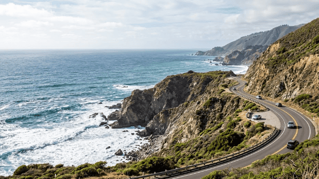
Big Sur
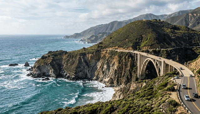
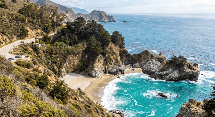
The section everyone drives the Pacific Coast Highway for. Dramatic cliffside views, redwood groves reaching nearly to the coastline, and landmarks like Bixby Bridge — one of the most photographed bridges in the country — define this roughly 90-mile stretch. McWay Falls, a waterfall dropping directly onto a beach within Julia Pfeiffer Burns State Park, ranks among the most distinctive single viewpoints on the entire route. Given the area’s history of landslides and narrow, winding roads, this is also the section where checking current conditions matters most, and where allowing extra driving time pays off given both the terrain and the volume of fellow travelers stopping at the same handful of pullouts.
Carmel-by-the-Sea and Monterey
Carmel offers a walkable, upscale coastal town experience with a notably strong concentration of art galleries and architecturally distinctive cottages, while neighboring Monterey is home to the Monterey Bay Aquarium, widely considered one of the best aquariums in the country and a strong stop regardless of whether you typically prioritize aquariums on a road trip.
Santa Cruz to San Francisco
The final stretch passes through Santa Cruz, known for its boardwalk and notably strong surf culture, before reaching the San Francisco Bay Area. Half Moon Bay, closer to San Francisco, offers a quieter coastal stop with strong seafood options before the trip concludes in the city itself.
Sample Itinerary: 7 Days, Los Angeles to San Francisco
Day 1: Los Angeles through Malibu to Santa Barbara, exploring the Mission and downtown area, overnight in Santa Barbara.
Day 2: Santa Barbara to San Luis Obispo via Solvang, a relatively light driving day allowing time for the Danish town detour.
Day 3: San Luis Obispo to San Simeon, with a half-day for Hearst Castle and the elephant seal rookery, overnight in Cambria or San Simeon.
Days 4-5: The full Big Sur stretch, ideally split across two days rather than one to allow real time at Bixby Bridge, McWay Falls, and the area’s numerous pullouts and short hikes, overnight in Big Sur or Carmel.
Day 6: Carmel and Monterey, including the Monterey Bay Aquarium, overnight in Monterey or Santa Cruz.
Day 7: Santa Cruz to San Francisco, with time for Half Moon Bay along the way, finishing in the city.
Best Time to Drive the Pacific Coast Highway
Spring (April-June) offers the strongest combination of factors: wildflowers blooming along coastal hillsides, generally clear skies before summer’s coastal fog season fully sets in, and lighter crowds than peak summer.
Summer (July-August) brings the heaviest crowds and, somewhat counterintuitively for a beach-adjacent route, frequent coastal fog, particularly in the mornings through Big Sur and the Bay Area approach. Afternoons typically clear, but morning fog can genuinely obscure views during exactly the hours many photographers want to be shooting.
Fall (September-October) is widely considered the unofficial best season by experienced Pacific Coast Highway travelers — fog has typically cleared from its summer peak, temperatures remain comfortable, and crowds thin noticeably from summer levels.
Winter (November-March) is the storm season, bringing both the most dramatic, moody coastal weather and the highest risk of the closures and landslide activity covered above. Winter can deliver genuinely striking photography for travelers comfortable with unpredictability, but it requires the most flexibility in trip planning of any season.
What to Pack for a Pacific Coast Highway Road Trip
A full tank of gas before entering Big Sur. Fuel options within the Big Sur stretch itself are limited and notably more expensive than surrounding towns — fill up in San Simeon, Cambria, or Carmel rather than counting on mid-route stations.
Patience for narrow, winding roads. Much of the Big Sur section has minimal shoulder space and frequent blind curves, meaning realistic driving speeds run well below posted limits for most of the route, especially with RVs or larger vehicles sharing the road.
Layers for coastal temperature swings. Coastal fog and onshore wind can make even summer days feel notably cooler than inland California temperatures at the same time of year, particularly in Big Sur and the Monterey/Santa Cruz stretch.
A physical, offline map as backup. Cell service drops out across significant stretches of Big Sur specifically, making offline navigation a genuine necessity rather than a nice-to-have.
Reservations for Hearst Castle and any Big Sur lodging well in advance. Both are popular enough, with limited capacity, that last-minute planning often means missing out entirely during peak season.
Where to Stay Along the Pacific Coast Highway
Big Sur lodging is notably limited in volume and correspondingly expensive relative to typical California lodging rates, given the area’s protected, low-development coastal status. Booking 2-3 months ahead for peak season is genuinely advisable rather than excessive caution.
Carmel and Monterey offer significantly more lodging volume and variety than Big Sur itself, making them a practical base for travelers wanting easier access to dining and amenities while still being close to the Big Sur stretch.
Santa Barbara and San Luis Obispo both function as comfortable, well-equipped overnight stops with a wide range of lodging options, from budget motels to higher-end resort properties.
Photography Tips for the Pacific Coast Highway
Golden hour transforms Big Sur’s cliffside views, with the low afternoon sun (since you’re driving northbound to southbound, facing roughly west toward the ocean for much of the route) creating dramatic lighting on the coastal cliffs that midday sun simply doesn’t replicate.
McWay Falls photographs differently depending on tide and time of day — the famous shot of the waterfall meeting the beach below requires specific viewing angle from the established overlook trail, and morning light generally outperforms afternoon for this particular spot given its east-facing cove orientation.
Bixby Bridge has a well-known pullout for the classic shot, located just north of the bridge itself along the Pacific Coast Highway, and it gets genuinely crowded during peak season — arriving early morning or late afternoon improves both lighting and the odds of an uncrowded shot.
Fog can either ruin or make a Pacific Coast Highway photo, depending entirely on how you use it. Summer morning fog through Big Sur frustrates photographers chasing clear coastal views, but the same fog, photographed thoughtfully, creates genuinely moody, atmospheric shots that clear-sky conditions can’t replicate.
A polarizing filter helps significantly with ocean glare at most coastal overlooks, cutting reflection and improving water color saturation in your shots.
Food and Wine Along the Pacific Coast Highway
The Pacific Coast Highway passes through some of California’s most distinctive food and wine regions, and treating the route purely as scenery misses a substantial part of what makes the trip worthwhile.
Santa Barbara’s wine country, just inland from the coastal route, has built a genuine reputation distinct from the more famous Napa and Sonoma regions, with the Santa Ynez Valley offering tasting rooms across a range of varietals well-suited to the region’s specific microclimate.
Carmel Valley, a short detour inland from Carmel-by-the-Sea, offers another strong wine region option, generally less crowded than Santa Barbara’s wine country given its smaller scale and lower profile among typical Pacific Coast Highway travelers.
Fresh seafood defines much of the route’s dining identity, particularly in Monterey and Santa Cruz, where the working fishing industry directly supplies many restaurants, and in Half Moon Bay near the trip’s northern end, known specifically for its Dungeness crab in season.
Cambria and San Simeon offer a more casual, small-town dining scene appropriate for a quick stop before or after the Hearst Castle visit, generally more budget-friendly than the higher-end options further along the route in Carmel.
What a Pacific Coast Highway Trip Costs
Lodging varies enormously based on how much time you spend in Big Sur specifically versus surrounding towns. Big Sur’s limited lodging supply commands premium rates, often $300-500+ per night for even modest accommodations during peak season, while Carmel, Monterey, and Santa Barbara offer a wider range from $150-400 depending on property and season.
Fuel costs run higher than a typical road trip given both the distance and the premium pricing within Big Sur’s limited gas stations specifically — filling up in larger towns before entering remote stretches saves meaningfully on cost.
Activities like Hearst Castle tours (roughly $30-50 per person depending on tour type) and Monterey Bay Aquarium admission (similarly in the $50 range per adult) add up across a multi-stop itinerary, worth budgeting for specifically rather than treating as incidental costs.
A realistic budget for a 7-day Pacific Coast Highway trip for two people, mixing mid-range and a couple of higher-end Big Sur nights, moderate dining with one or two wine country or seafood splurges, and the major paid attractions, typically lands in the $2,000-3,500 range, not including flights to a starting point like Los Angeles or San Francisco.
Getting to the Pacific Coast Highway
Flying into Los Angeles (LAX) suits travelers planning to drive the Pacific Coast Highway northbound to southbound in reverse, or starting from the south and ending in San Francisco.
Flying into San Francisco (SFO) works for travelers ending their Pacific Coast Highway trip in the Bay Area after driving the recommended northbound-to-southbound direction from Los Angeles, requiring either a one-way rental car return (typically carrying an extra fee) or a flight back to your starting airport.
One-way car rentals between Los Angeles and San Francisco are common enough for this specific route that most major rental companies handle them routinely, though the additional drop-off fee is worth comparing across providers before booking, since it varies considerably.
Underrated Pacific Coast Highway Stops Most Travelers Miss
Beyond the famous landmarks covered above, a few Pacific Coast Highway stops consistently surprise travelers who weren’t expecting much from them.
Pfeiffer Beach, accessed via an easy-to-miss, unmarked turn off the Pacific Coast Highway in Big Sur, features striking purple-tinted sand (caused by manganese garnet deposits washing down from nearby hillsides) and a dramatic rock arch formation that creates a natural keyhole effect at sunset, when light passes directly through the opening.
Point Lobos State Natural Reserve, just south of Carmel, offers some of the most accessible and rewarding short hiking trails along the entire route, with consistently strong wildlife viewing including sea otters, harbor seals, and abundant bird life, all within walking trails suitable for most fitness levels.
Moss Landing, between Santa Cruz and Monterey, is a small working harbor town that draws far less Pacific Coast Highway tourist traffic than its neighbors despite offering some of the best sea otter viewing along the entire route, directly visible from the harbor without any hiking required.
Montaña de Oro State Park, near San Luis Obispo, delivers dramatic bluff-top hiking with sweeping coastal views and a fraction of the crowds found at more famous Big Sur viewpoints, making it a strong stop for travelers wanting a genuine hike without fighting for parking or trail space.
Combining the Pacific Coast Highway With Other Trips
Given its position connecting Southern and Northern California, the Pacific Coast Highway naturally extends into several other popular itineraries. Travelers starting from Los Angeles can extend southward into San Diego before beginning the main northbound route, adding a few extra days to an already substantial trip. On the northern end, San Francisco connects naturally to further exploration of Northern California’s wine country, the Redwood Coast further north, or a detour east toward Yosemite National Park, all reasonable additions for travelers with extra time beyond the core coastal drive.
For travelers connecting from elsewhere in the Southwest, the Pacific Coast Highway pairs less directly with desert-focused destinations like Las Vegas or the Grand Canyon — these require a meaningful inland drive to connect with the coastal route, generally treated as a separate trip segment rather than a seamless extension of the same itinerary, though some longer, multi-week Western road trips do combine both halves into one extended journey.
Common Mistakes to Avoid on the Pacific Coast Highway
Driving the route southbound when northbound serves the views better. As covered above, northbound to southbound keeps you on the ocean side of the road for most of the narrow coastal sections — a detail that genuinely changes the visual experience of the entire trip.
Rushing through Big Sur in a single day. This is the section the entire route is famous for, and treating it as a quick pass-through rather than the trip’s centerpiece is the most common regret shared by Pacific Coast Highway travelers after the fact.
Not checking current road conditions close to departure. Given the route’s documented history of landslides and ongoing maintenance work, assuming any single source’s conditions information stays accurate for months is a planning risk specific to this particular road trip.
Underestimating drive times due to the road’s curves and narrow sections. A glance at total mileage understates how long the Big Sur stretch specifically takes to drive safely and enjoyably — budget meaningfully more time per mile here than on a typical highway.
Skipping the inland detour towns in favor of staying purely coastal. Solvang’s Danish theme and Carmel Valley’s wine country both offer worthwhile breaks from coastal driving, and travelers who stick rigidly to the highway sometimes miss these distinctive nearby stops.
A Bit of History
The Pacific Coast Highway as a continuous coastal route took shape gradually through the early-to-mid 20th century, with the most challenging engineering section through Big Sur — connecting what had previously been isolated coastal communities accessible mainly by sea or arduous inland routes — completed in 1937 after nearly two decades of construction across genuinely difficult cliffside terrain. The Bixby Bridge, completed in 1932, remains one of the signature engineering achievements of this era, allowing the route to span a deep canyon that had previously required a lengthy inland detour.
This history matters for understanding why the Pacific Coast Highway remains so prone to landslide closures even today: the route was built directly into naturally unstable cliffside terrain, prioritizing the most dramatic possible coastal views over the kind of more conservative, inland routing that would have avoided decades of recurring slide damage. It’s a trade-off that’s defined the road since construction, and one that — based on the route’s continued popularity despite regular closures — most travelers clearly consider worth the occasional inconvenience.
The “PCH” abbreviation itself, now used almost universally by both locals and tourists, became shorthand specifically for the Southern California urban sections of the route (through Malibu and Orange County) in popular usage, even though the full Pacific Coast Highway designation technically extends much further north through Big Sur and beyond.
Frequently Asked Questions
Is the Pacific Coast Highway fully open in 2026? Yes, as of January 14, 2026, the previously closed Regent’s Slide section in Big Sur has reopened, restoring full continuous travel through the entire Big Sur stretch for the first time since 2023. That said, given the route’s history, always verify current conditions through Caltrans QuickMap close to your travel dates, since brief storm-related closures remain a possibility.
How long does it take to drive the Pacific Coast Highway? A non-stop drive from Los Angeles to San Francisco takes roughly 8-9 hours of pure driving time, but most experienced travelers recommend spreading this over 5-7 days minimum to actually experience the route’s stops and views rather than just passing through.
Is the Pacific Coast Highway dangerous to drive? The route involves narrow, winding cliffside sections, particularly through Big Sur, that demand real attention and reduced speeds, but it’s a well-maintained, regularly traveled road that millions of visitors drive safely each year. Respecting posted speed limits, allowing extra time, and avoiding driving in dense fog or storm conditions are the main practical safety considerations.
Can you drive the Pacific Coast Highway in an RV? Yes, though larger RVs and trailers face more challenging conditions on Big Sur’s narrowest sections and tightest curves than a standard car. Smaller campervans and Class C RVs handle the route reasonably well in good weather; larger Class A motorhomes require more caution and slower speeds throughout the coastal stretch.
What’s the best month to see whales along the Pacific Coast Highway? Gray whale migration is visible from numerous coastal viewpoints along the route primarily from December through April, with the southbound migration (December-January) and northbound return (March-April) offering the strongest viewing windows, particularly from elevated viewpoints in Big Sur and Monterey.
Do I need reservations to drive the Pacific Coast Highway? No reservation or permit is required simply to drive the route itself. However, specific attractions along the way — Hearst Castle tours in particular, and popular Big Sur lodging during peak season — do require advance booking given limited capacity, so reserve these pieces separately well before your trip.
Final Thoughts
The Pacific Coast Highway’s full reopening after three years of partial closure makes 2026 a genuinely meaningful year to finally drive this route end to end, particularly if you’ve been holding off specifically because of the Big Sur access issues. The combination of dramatic coastal cliffs, redwood groves, and small towns with real character — not manufactured tourist-trap versions of it — remains hard to match anywhere else in the country for a road trip of this length.
Plan for narrow roads and real driving time through Big Sur specifically, check current conditions close to departure given the route’s documented history, and resist the urge to rush through the trip’s best section just to say you finished the drive. Whether this is your first time on the Pacific Coast Highway or a return trip now that the full route is finally connected again, the road rewards travelers who slow down more than almost any other road trip in America — and after three years of partial access, that’s an experience worth taking the time to properly enjoy.